Fostering Historical Awareness with Educational Wooden Maps
In today’s digital age, where information is just a click away, the importance of tangible, visual learning tools remains undeniable. Among these tools, the Wooden Map stands out as a unique, engaging means of fostering historical awareness and geographical literacy. This article delves into how educational wooden maps serve as vital instruments in teaching history, geography, and cultural understanding. By integrating artistic craftsmanship with educational content, wooden maps create an immersive learning environment that appeals to students, educators, and history enthusiasts alike.
The Power of Visual Learning: Why Wooden Maps Are Effective Educational Tools
Visual aids are fundamental in effective education. They simplify complex information, elevate engagement, and facilitate better retention. Wooden maps, with their tactile and three-dimensional qualities, offer a compelling visual and physical experience.
The Educational Value of Tactile Learning Tools
Unlike traditional textbooks or digital screens, physical learning aids like wooden maps provide tactile engagement, which enhances cognitive processing. When students can touch and interact with a wooden map, their understanding of spatial relationships and geographical contexts deepens.
Tactile learning stimulates different areas of the brain compared to visual or auditory learning. This multisensory approach leads to better memory retention and a more profound grasp of historical and geographical concepts.
In the context of history education, tactile maps help students understand movement patterns, territorial changes, and cultural diffusion more concretely. For example, tracing the routes of explorers or migration paths on a wooden map makes these historical journeys more tangible and impactful.
How Wooden Maps Make History Come Alive
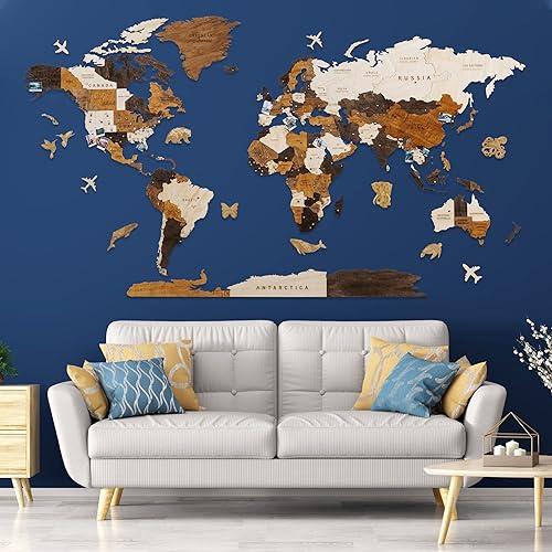
A wooden map brings history from the pages of textbooks into the physical space. Its three-dimensional design can incorporate layered elements representing different eras or civilizations, creating a timeline in a spatial form.
For instance, the layered topography can distinguish ancient borders from modern ones, illuminating the dynamic nature of political geography. Additionally, maps with incorporated push pins and markers allow for interactive storytelling—highlighting significant events, certain territories, or migration routes, making history immersive and personal.
Moreover, these maps are not static; they can become centerpieces for projects, exhibits, or classroom activities that foster curiosity and dialogue. By physically engaging with a map, learners forge an emotional connection to historical events, fostering empathy and a more nuanced understanding.
Enhancing Cultural and Historical Awareness Through Artistic Craftsmanship
The beauty of wooden maps extends beyond their educational utility—they are works of art. This craftsmanship enhances the learning experience by creating a memorable visual appeal that stirs curiosity and pride.
A well-crafted wooden map can include engraved facts or quotes, historical landmarks, or cultural symbols, blending artistic elegance with educational content. This fusion of aesthetics and knowledge makes the map not just a teaching aid but also an inspiring decorative piece.
In classrooms or homes, such maps serve as constant visual reminders of history’s complexity and richness. They encourage exploration and discussion across generations, serving both as learning tools and as decorative testimonies to cultural heritage.
How to Integrate Wooden Maps into Educational Settings

Incorporating educational wooden maps into learning environments requires thoughtful planning, creativity, and a clear understanding of pedagogical objectives. Here’s how educators and parents can maximize their potential.
Utilizing Wooden Maps for Interactive Classroom Activities
An effective way to leverage these maps is by designing interactive lessons that cultivate curiosity and critical thinking.
For example:
- Historical expeditions: Students can identify routes taken by explorers or armies and trace them on the map.
- Cultural Mapping: Mark regions of cultural significance, festivals, or migration patterns.
- Historical Timeline Projects: Create layered maps representing different eras, encouraging students to compare and analyze changes over time.
Encouraging students to use push pins or markers to denote places of significance fosters active participation and personalization. This hands-on approach facilitates active learning and helps students internalize geographical and historical concepts.
Using Wooden Maps for Family Learning and Home Decor
Parents can integrate wooden maps into home classrooms or family spaces to create ongoing educational opportunities.
Placing a wooden map in a family room can spark spontaneous conversations about world history, geography, or personal travel stories. Involving children in marking places they or their ancestors are connected to nurtures a sense of identity and global awareness.
Additionally, wooden maps serve as captivating home decor, combining aesthetic appeal with educational function. They can inspire children to explore the world beyond their immediate environment, fostering global citizenship from an early age.
Incorporating Wooden Maps into Museum Exhibits and Cultural Centers
Museums and cultural centers can utilize wooden maps to create engaging exhibits that commemorate historical events, voyages, or territorial evolutions.
A map showcasing the routes of historical explorers, colonial expansions, or migration patterns becomes an immersive narrative. Visitors can interact with the map—adding pins, following routes, or reading engraved facts—turning passive observation into active learning.
This approach enhances visitor engagement and deepens understanding, especially for visitors of varying ages and educational backgrounds.
The Role of Wooden Maps in Preserving Cultural Heritage and Promoting Global Awareness

Cultural preservation and global awareness are vital components of education. Wooden maps can serve as powerful tools in these areas by encapsulating history, geography, and cultural narratives in a physical form.
Highlighting Historical Landmarks and Cultural Sites
Many wooden maps feature engraved or marked locations of historical and cultural importance. These highlights provide visual anchors that help users understand the significance of places and their stories.
For example, a map depicting the Silk Road might showcase key trading cities, ancient routes, and cultural exchanges. These visual cues spark curiosity about the interconnectedness of civilizations and their shared history.
Promoting Diversity and Cultural Understanding
Educational wooden maps can be customized to emphasize cultural diversity. They can showcase indigenous territories, minority cultures, or important landmarks from different regions.
Such representations foster appreciation and understanding of cultural diversity, promoting respect and empathy across communities.
Fostering a Personal Connection to History and Geography
A wooden map often acts as a personal artifact—be it in a classroom, museum, or family home. It encourages users to connect personally with historical narratives, whether by marking places of personal significance or exploring stories from different parts of the world.
This personal engagement deepens the impact of educational content, making history and geography more memorable and meaningful.
The Benefits of Educational Wooden Maps Over Digital Alternatives

While digital maps and interactive apps offer convenience and connectivity, educational wooden maps possess distinct advantages that can enhance learning experiences.
| Feature | Wooden Maps | Digital Maps |
|---|---|---|
| Tactile Engagement | Yes | No |
| Physical Presence | Yes | No |
| Artistic Craftsmanship | Yes | Limited to visual display |
| Personalization Options | High (Markers, engravings) | Limited to software capabilities |
| Durability and Longevity | Long-lasting, heirloom quality | Digital files may become obsolete or inaccessible |
| Educational Impact | Promotes active, multisensory learning | Passive or visual-based learning |
While digital maps are useful for immediate, broad visualizations, the tactile and artistic qualities of a *wooden map promote deeper, more personal learning experiences.*
In particular, animated features or real-time data overlays are fascinating, but they often lack the physicality and emotional resonance that a handcrafted wooden map offers.
Practical Tips for Choosing and Using Wooden Maps for Education

Selecting and effectively utilizing a wooden map requires some planning. Here are practical considerations for educators and parents.
Factors to Consider When Choosing a Wooden Map
- Size and Space: Ensure the map fits well into the intended space and is accessible for interaction.
- Detail and Features: Decide whether you want a simple outline or a detailed map with engravings of landmarks, borders, or cultural sites.
- Customization Options: Look for options to add pins, labels, or personalized engravings.
- Educational Focus: Choose maps that highlight specific themes relevant to your curriculum—whether world history, regional geography, or cultural heritage.
- Material and Craftsmanship: Opt for maps made from durable, high-quality wood to ensure longevity.
Effective Ways to Incorporate Wooden Maps into Learning Activities
- Interactive Quizzes: Use the map for geography quizzes, asking students to locate places based on clues or historical events.
- Storytelling Sessions: Narrate historical stories linked to places marked on the map, enhancing storytelling with visual cues.
- Travel Planning Activities: Encourage students to plan hypothetical or real voyages, fostering interest in world exploration.
- Cultural Celebrations: Mark locations of significant cultural festivals or historical milestones during relevant occasions.
Maintaining and Preserving Wooden Maps
Proper care extends the life and maintains the appearance of wooden maps:
- Cleaning: Dust regularly with a soft, dry cloth.
- Avoid Moisture: Keep away from excessive humidity to prevent warping or damage.
- Protection: Consider applying a light coat of wood conditioner or polish periodically.
- Handling: Minimize rough handling to prevent scratches or loosening of engravings.
Conclusion

Educational wooden maps are invaluable tools in fostering historical awareness, geographical literacy, and cultural understanding. Their tactile nature, artistic craftsmanship, and customizable features make them uniquely effective in diverse educational settings—from classrooms and museums to family homes. These maps bring history to life, creating memorable learning experiences that transcend the limitations of digital media.
By integrating wooden maps into educational activities, educators and learners can foster curiosity, empathy, and a deeper appreciation of the world’s diverse cultures and histories. Whether highlighting ancient trade routes, territorial changes, or cultural landmarks, wooden maps serve as tangible gateways to understanding our shared past and interconnected present.
Investing in a high-quality wooden map not only enhances educational engagement but also creates a timeless piece that can be treasured and passed down through generations, inspiring curiosity and learning for years to come.